Satellite Eyes in the Sky Track Massive Saharan Dust Storm Across Northwest Africa
Satellite Eyes in the Sky Track Massive Saharan Dust Storm Across Northwest Africa
By the Science Desk thenews9.org
In early spring 2026, a massive wall of dust swept across northwestern Africa, painting the skies in hazy hues and triggering severe weather alerts. Driven by a powerful, dry wind known as the harmattan, the storm originated in the Sahara Desert and was closely monitored by a fleet of international weather satellites as it marched toward the Atlantic Ocean.
The Anatomy of a Dust Storm
The driving force behind this massive dust plume was the harmattan—a dry, dust-laden wind that typically blows from the northeast between November and April.
According to Spain’s state meteorological agency (AEMET), the events of March 30 were the result of a specific weather pattern known as a “harmattan surge.” This occurs when a passing cold front causes winds to intensify near the ground. On that day, the winds converged perpendicularly against the High Atlas mountain range in Morocco before aggressively shifting southwest, scooping up massive amounts of Saharan sand and dust along the way.
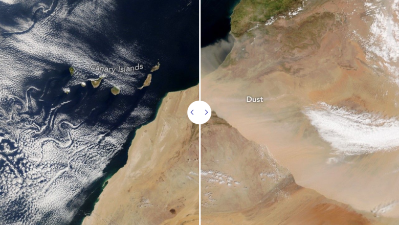
Eyes in the Sky
Because of the sheer scale of the event, scientists and meteorologists were able to track the storm’s progression in real-time using multiple satellites:
- NASA’s Terra Satellite: Captured the initial scale of the dust wall at approximately 10:00 Universal Time (11:00 a.m. local time in Morocco) as it began its journey southwest.
- NOAA-21: Snapped subsequent imagery about four hours later, documenting the storm’s rapid spread.
- Meteosat-12: Operated by the European Organization for the Exploitation of Meteorological Satellites (EUMETSAT), this geostationary satellite provided continuous tracking as the dust plume moved menacingly close to the Canary Islands.
Immediate Impacts and ‘Calima’
The immediate effects of the storm were felt in Morocco, where officials were forced to issue weather alerts for several regions due to dangerously low visibility and harsh, choking conditions.
However, the storm’s reach extended far beyond the African coastline. Forecasts predicted the dust would ultimately engulf the Canary Islands, triggering a local atmospheric phenomenon known as calima. The thick airborne dust was expected to significantly degrade air quality and visibility across the island chain through April 1. This event followed closely on the heels of another storm earlier in March that sent dust toward both the Canaries and mainland Europe.
A Seasonal Phenomenon
While striking, this massive dust storm is part of a well-documented seasonal cycle. Researchers utilizing NASA data have noted that spring is the peak season for the most intense Saharan dust storms. During this time of year, weather patterns are perfectly positioned to lift dust from the vast sand seas—known as ergs—of central North Africa and the Mediterranean coast, sending millions of tons of dust swirling into the global atmosphere.